Saturday, August 29, 2009

Day 20 - (08/29) Springdale, UT

Our plan to get up and sight see early really paid off. It was 101° at noon today when we finished our Zion Canyon hikes.

We took a shuttle bus to the farthest stop on the route (at Temple of Sinawava), then took the 2 mile Riverside Walk to where the path ends in a true “river walk”. See proof below.

The canyon narrows as the path follows the Virgin River

This is what we saw at the end of the path

Hmm, should we get wet?


This is where we decided to turn back


OK, I'm coming back

Others will see the canyon narrow to 20ft up ahead

We sloshed back from the Narrows and finished our hike at Weeping Rock. In case you didn't know, wet shoes are REALLY heavy.

View from Weeping Rock

Carol under the Weeping Rock overhang. It's "crying" all around her.


FYI:

There are fires to the northwest. Dark smoke clouds moved over the park late this afternoon. We're assured there's no risk here.

Interesting Sight:

This Bavarian camping tour bus was parked near us. The front half had standard tour bus seats, the back half had sleeping accommodations. Cooking accessories were in storage compartments below. Carol went to say hello and discovered everyone spoke German. Their conversation was pretty short.

Friday, August 28, 2009

Day 19 - (08/28) Springdale, UT

The day we stopped traffic …

We drove from Bryce to Zion NP today and didn’t take any side excursions. The 84 mile trip (UT 12W, US 89S, UT9W) took 3 ½ hours. Pretty slow, huh? Zion National Park Scenic Byway (UT 9) gets most of the credit. There are many places where the speed limit is down to 15 mph. We went through two tunnels. The second tunnel is a mile long, was built in 1930, and is narrow. Some large vehicles (we’re included here) have to pay a fee and be escorted through … they stop traffic coming the other way and you drive down the center of the roadway. Some large vehicles don’t get to go through at all.

We’re staying at Zion Canyon Campground just outside the park entrance.
Here's a view from the front of the trailer

Zion operates a free shuttle system that greatly reduces private vehicle traffic and pollution in the park. The summer buses start at 5:45am, end at 11:00pm, and run 6 to 15 minutes apart.

It’s 106° at Zion NP today. We waited until 6pm to enter the park and start our look around. We took the shuttle from the visitor center to the museum, then walked the Pa’rus Trail to Canyon Junction, rode to Court of the Patriarchs, then rode the bus to the end of the route and returned to the visitor center at 9pm.

What a view as the sun sets!

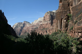
The Virign River continues to shape Zion Canyon

Pa'rus Trail along Virgin River - see the heron?


The Patriarchs - Abraham (L), Isaac (C), Jacob (far R)

We saw buffalo, alpaca, mountain goats, mule deer, wild turkeys, a heron and a gray fox today.
Did you know?
* Zion Canyon is believed to be the deepest sandstone canyon in the world. It was (and is being) formed by the Virgin River.

* The floor of Zion Canyon is at the same elevation as the top of the Grand Canyon.

* Water seeping out of the Zion Canyon walls has been dated at 1200 years old.

* There are more, different types of vegetation in Zion Canyon than in Hawaii.

* The Virgin River moves 50,000 tons of sediment per day.


Day 18 - (08/27) Bryce Canyon, UT

The morning drive to Bryce Canyon was 115 miles on UT Scenic Byway 12. The travel guide says … “This remote highway snakes along narrow ridge tops, carves through red-rock canyons past prehistoric Native American ruins, and ascends 11,000-foot Boulder Mountain for breathtaking views.” We saw it a little differently … 14% grades, sharp curves, switchbacks and 6 miles on the “Hogback”. The Hogback is a 2-lane road on a narrow ridge where sections were only as wide as the road … that means straight drop-offs on both sides with only the horizon and valleys far below in view.
We stopped at the Anasazi State Park on the way. They had a very nice museum offering a close-up view of the ancestral Pueblo people. Sorry, no pictures from here.

We toured Bryce Canyon NP after set up at Ruby’s Inn and RV Resort (just outside the park entrance).
There are great sights here!

Natural Bridge was misnamed. It was formed by rain and frost erosion, not by a stream.

Some Hoodoos seem to stand alone
Amphitheater from Bryce Point
See the hikers below?


Hoodoos cover the landscape.

Daytime temp was mid-80s, evening temp was in low 40s.

Did you know?
Those spire-like things above are called "Hoodoos". They are pillars of rock, usually of fantastic shape, left by erosion. Strange name ... strange shapes.

Thursday, August 27, 2009

Day 17 - (08/26) Torrey, UT

This was a day to see Capitol Reef National Park. We’d never heard of it until yesterday. Now we discover it preserves the “Waterpocket Fold” created by vast warping of rock when the Colorado Plateau shifted 65 million years ago.

View from Goosenecks Overlook

We have the park to ourselves

Grand Wash drive had many cautions about storms and flash floods.

Thousand Lakes RV Park has been very nice. Here's our view from the front of the trailer.

Try this place …
Slacker’s Burger Joint in Torrey, UT is a fun place for a sandwich dinner or ice cream treat. The place is far from fancy, but their hamburgers are outstanding! The owners came to our table to share travel experiences … nice folks. Caution: they collect license plates for display on the restaurant walls and ceiling.

Tuesday, August 25, 2009

Day 16 – (08/25) Torrey, UT

We headed west toward Bryce Canyon and Zion parks today. The 288 mile drive from Mancos, CO to Torrey, UT provided new and dramatic scenery.

We took the Bicentennial Highway (UT 95N) from Blanding to Hanksville, stopping at Natural Bridges National Monument on the way.

Are there really bridges in here?


It's hot and dry out here.

Sapapu Bridge

Kachina Bridge

Owachomo Bridge


The route passed through Glen Canyon National Recreation Area. We could see Lake Powell in the distance. The Dirty Devil and Colorado rivers join just above Lake Powell.

We took UT 24W from Hanksville to Torrey. The landscape changes from CO through UT were awesome.
There were some serious ascents and descents (10% grades) on this trip. Some of the climbs were pretty slow. Fortunately, there was very little traffic.

We’re at Thousand Lakes RV Park in Torrey and will stay here a few days to check out the area.


Did you know?
How bridges and arches differ ... Natural bridges are formed by the erosive action of moving water. Arches are formed by other erosive forces, mainly frost action and seeping moisture. The same forces that form arches also work to enlarge natural bridges after stream erosion forms them.

Monday, August 24, 2009

Day 15 - (08/24) Mancos, CO

Mother Nature has offered us something new every day. We won’t attempt to rate one experience over another, but today offered some treats you may want to try.

We took the San Juan Skyway scenic drive in Colorado. The routes (US 160W, CO 145N, CO62E, US 550W, US 160W) took us to Cortez, Telluride, Ouray, Silverton and Durango. The weather was overcast most of the day with misting and heavy rain during short periods. The drive included numerous climbs to over 11,000ft elevation, sharp switchbacks, no shoulders or guardrails in some places and breathtaking views.

Telluride
We stopped at the Telluride Mountain Village (ski resort) and took two free gondola rides down the mountain to Telluride (the city). We enjoyed a great brunch at Maggie’s, viewed some historic buildings and escaped the tourist traps unscathed.

Mountain Village from gondola

Telluride (the city) from gondola

Pat and Cindy (from Sarasota, FL) at Maggie's. Pat lived in Chagrin Falls, OH and has a grandson who lives in Victorian Village and attends OSU ... small world.

Ouray
This little mining town has done much to attract tourists. The Box Canyon Park and waterfall sure got our attention. A deer almost ran into us as Carol drove down the main street.

View from 200ft above waterfall

Carol on catwalk leading to the waterfall. Same catwalk viewed from 200ft above.

Silverton
This mining town had many restored Victorian homes and retained much of its old west charm. It didn’t look as prosperous from tourist trade as Telluride and Ouray. Only the main street was paved.


Durango
It was raining hard with wind and lightning when we got to Durango. We didn’t stop. The sky cleared and the sun was shining brightly when got back to the campground (just 36 miles away).

A great place to see:
Box Canyon Park at Ouray offers a thunderous view of a waterfall plume plunging over smooth walls of dark limestone. The Falls Trail and High Bridge Trail are well worth the effort.

A great place to eat:


Maggie's Bakery & Café in Telluride offers small-town atmosphere, friendly service and outstanding pecan sticky buns. It's located on Main St.

Sunday, August 23, 2009

Day 14 - (08/23) Mancos, CO

We finished our time at Mesa Verde NP with a ranger-lead tour of Long House and viewed Kodak House from a tram. It’s been a wonderful experience. We’ll take off on a new adventure tomorrow.

Long House - from overlook

Long House
Carol and Ranger Beth
Kodak House
We finished the day with some housecleaning (window washing, vacuuming). After 10 minutes of intense labor we headed off to the Dairy Queen in Cortez for a reward.
Something to try:
Navajo Taco - it's created atop plate-sized rounds of crispy Navajo fry bread. Add chopped lettuce, tomatoes, chili/chicken or vegetarian sauce, shredded cheddar cheese, sour cream, salsa and other garnishes. Carol tried green chili ... it was too hot to handle. This is a great dish if you're careful with the garnishes.

Saturday, August 22, 2009

Day 13 - (08/22) Mancos, CO

We drove 26 miles into Mesa Verde NP and climbed to Chapin Mesa (7,000ft). In doing so we were able to take three tours and look back in time at cliff dwellings built by the Anasazi. Though the Anasazi left no written record, it’s believed the structures here were built between 550 and 1300A.D. The experience was unforgettable. We hope you enjoy the views as much as we did.

Cliff Palace
This ranger-guided tour involved descending uneven stone steps and ascending five ladders for a 100ft vertical climb. This dwelling had more than 150 rooms and took about 100 years to build.

Up close

View of "the city"


Balcony House
This ranger-guided tour involved climbing a 32ft ladder, crawling through a 12ft-long tunnel, climbing up a 60ft open cliff face and two 10ft ladders to exit the site. This dwelling is believed to be one of the last built.

The ranger said not to look up or down.


It's a neat place with a great view.

This is the original entrance and exit.


Spruce Tree House
This self-guided tour of Mesa Verde’s best-preserved cliff dwelling involved a steep descent and ascent, but no ladders or tunnels.
Carol - in front of a small section of Spruce Tree House

Dick enters a ceremonial room called a "kiva"

Did you know?
Mesa Verde National Park is America’s first World Heritage Site.